Computerized FGM Design and Construction for Land Reclamation
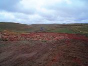
This one's a peak into the future. Yet it's being done now. Traditional land reclamation for abandoned mine lands sites is based on returning the disturbed land to it's "approximate original contour" (AOC). While it sort of looks like the land as it was before mining, it usually has an engineered look that you can spot like a bad toupee. And like a bad toupee, this kind of reclamation doesn't behave like the real thing either. The original landscape had to be shaped over a long period of time to shed water and hold vegetation without degradation. The engineered designs don't include the richness and subtlety in contour needed to behave in a way that sustains itself over the long haul. Until recently, AOC is about as good as could be done. That's all changing.
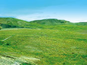
Based in concepts of fluvial geomorphology, practitioners are now able to design landscapes that look and act like the real deal. And get this... if you have the right tools, it's a lot cheaper and easier to do it the better way! Yes, it takes some high-tech, wiz-bang tools and the mastery of them, but beyond that there appears to be little downside. Not only is design made easier via this process, but the actual construction phase can be automated using GPS technology.
The following side-by-side comparison was taken directly from Carlson Software website on its "Natural Regrade" software
| Old method |
Natural Regrade
software with GeoFluvT |
|||||||||||||||||||||||||||||||||||||||||||||
 |
 |
|||||||||||||||||||||||||||||||||||||||||||||
|
|
Carlson Software - Land Development Engineering Resources